

People know that Mark and I enjoy Hawai’i Island—a lot. That we vacation there as often as we can (not often enough!) and that we have numerous friends there (and, yes, most of them are in some way “ukulele people”).
That’s why, I think, I’m on the receiving end of so many questions lately about “the volcano.” I’ve searched out a few links which I refer to so I can stay informed—and I’m sharing my favorites with you here.
Note: I prefer these sources to simply doing a Google search for “Hawai’i volcano” because they’re more local (nothing like getting alarmist headlines from a Google search and then realizing they’re from a story in a sensationalist English newspaper dated 15 days earlier…).
First person accounts, news and videos: Mileka Lincoln is doing a simply incredible job with on-the-ground reporting about this situation for HawaiiNewsNow (television). But you don’t need to tune in to tv to see her reports. She posts multiple times a day on her Facebook account. No need to be a Facebook “member” to watch them, either. Go here.
Ikaika Marzo is a Pahoa-area resident that is documenting the enormous scale of this event within his community. Count on videos, interviews with neighbors, photos and a real world account of what it’s like in the area. Go here.
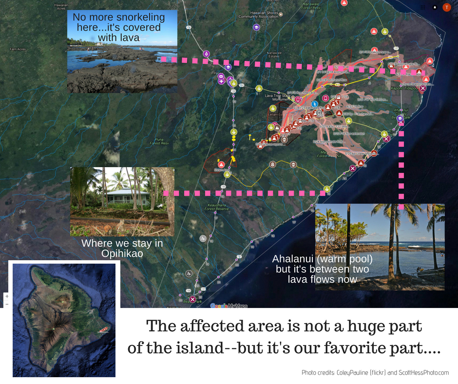
A great map for details–updated daily with lava flow and fissure activity: The Island of Hawai’i is big—the biggest in the state—but many people have a hard time figuring out where the Lower East Rift Zone is that’s spouting off all the lava. Hint: Only a tiny portion of the island is at risk for lava inundation and volcanic activity right now (if you don’t count the earthquakes). For those in this area, it is certainly devastating. Homes have disappeared under mountains of lava, roads are covered and other byways are barely passable due to cracks. Utilities such as phone, water and electricity are sometimes gone entirely.
But despite the sensationalized news, the eruption doesn’t affect all of Hawai’i Island. Look at this map and you’ll be able to better put it in perspective. What’s especially valuable about this map is that it’s updated daily and includes all the fissures, flows and volcanic activity, overlaid on a Google map. It’s on my “favorites” in my bookmarks bar for a quick check of status.
First person accounts and videos: For official and scientific news, go here to read articles and see photos from the USGS Hawaiian Volcano Observatory. This includes webcams in the various caldera areas, maps, information about earthquakes and lots of data, if you’re so inclined.
From a “local” news standpoint: This is an online newspaper for Hawai’i Island that’s featuring stories reflecting the human element of this volcanic event.
This screenshot of the above-linked map shows where we usually vacation (it’s about one mile from what was an active lava flow in May). We had November reservations to stay in this area (which is near the home/workshops of Bonnie and Chuck Moore, Moore Bettah Ukes, but the cottage’s owner contacted us and said it won’t be possible due to bad air and access issues.
Sigh… I’m not sure what the Hawaiian word is for “really disappointed” but consider it uttered.